
Aeronautical Sectional Charts
FAA-CT-8080-2H Airman Knowledge Testing Supplement
Direct link to FAA web page:
https://www.faa.gov/training_testing/testing/supplements
An aeronautical sectional chart is a roadmap for the skies and provides the airspace boundaries for class B, C, D, E, and G airspace. In addition, a sectional chart also includes the locations of manmade obstacles such as broadcast towers, Military Flight Routes (MFR), power lines, prohibited and restricted flight areas, and glider and parachute jumps areas, just to name a few. At first you may find sectional charts to be a little overwhelming but after a while, it will become second nature as we work a lot with symbols. The FAA wants the remote pilots to become familiar with sectional charts, as these charts will help the remote PIC avoid accidents and conduct flight operations in the safest manner possible. Aeronautical sectional charts are perhaps one of the most important sections to study as about 20% or more of your final exam will pertain to aeronautical sectional charts. It’s recommended that you download the FAA-CT-8080-2H Airmen Knowledge Testing Supplement as you will often need to refer to it throughout this chapter.
Class B Controlled Airspace
Class B airspace is controlled airspace and is shown as solid blue circles and will be seen at major airports like Boston, Atlanta, Philadelphia, New York, Los Angeles, and Chicago. The inner-most circle of Class B airspace is typically from the surface (SFC) up to 10,000 feet MSL however the ceiling can vary from 7,000 to 12,000 feet MSL depending on the airport’s location, surrounding natural terrain, and/or manmade obstacles.
The floor and ceiling of the airspace are indicated by what appears as blue fractions, with a larger 2 or 3-digit number over a smaller 2-digit number. At Philadelphia Airport, which is a pretty large airport, there are three tiers of airspace shelf involved. The center of the airport extends 5 miles outward from the airport and includes airspace from the surface (SFC) and also from 300 feet MSL to 7,000 feet MSL. The floor and height of airspace is shown in hundreds of feet with two-zeros excluded, so 03 becomes 300 feet, 70 becomes 7,000 feet MSL, and so on.
The first shelf of airspace includes airspace from 1,500 feet to 7,000 feet MSL; the second shelf of airspace begins at 2,000 feet MSL and extends up to 7,000 MSL, and the third shelf of airspace begins at 3,000 feet MSL, and also 3,500 feet MSL in some areas, and extends up to 7,000 feet MSL. And if you look at the far right and left of the sectional chart for Philly, you’ll notice two small sections of airspace that are actually a fourth shelf of airspace that begins at 4,000 feet MSL and extends up to 7,000 feet MSL, and this is to provide additional airspace clearance for the end of the runways that runs somewhat east to west. It’s also worth noting the blue runways at Philadelphia which indicates the runways are greater than 8,069 feet in length, and the blue star indicates this is an active control tower at the airport. If you notice other larger blue dots/airports, to the north east of Philadelphia (see North Philadelphia), that round blue circle/dot indicates a towered airport as well but with runways less than 8,069 feet in length.
Class C Controlled Airspace

Class C airspace is controlled airspace and is depicted with solid magenta circles or lines, and will been seen at slightly smaller airports such as Atlantic City, Baton Rouge, and Savannah, Georgia. Class C airspace typically runs from the surface (SFC) up to 4,000 feet MSL but again, depending on ground elevation and other factors, the ceiling could run up to 4,500 or even 5,000 feet MSL. The innermost circle at Atlantic City International extends from the surface (SFC) to 4,100 feet MSL, and the outer circle denotes airspace from 1,300 feet MSL to 4,100 feet MSL. Like Philadelphia Airport, the blue runway icon indicates the runways are greater than 8,069 feet in length, and the blue star indicates this is a towered airport. Also depicted in this chart is some Class E airspace, which is shown as shaded magenta lines/circles, denotes the lower shelf of airspace begins at 700 feet AGL and 1,200 feet AGL. That is, the inside of the Class E shaded airspace begins at 700 feet AGL, and the outside edge of the magenta shaded circle indicates airspace that begins at 1,200 feet AGL. We’ll be reviewing Class E airspace in greater detail below.
Class D Controlled Airspace
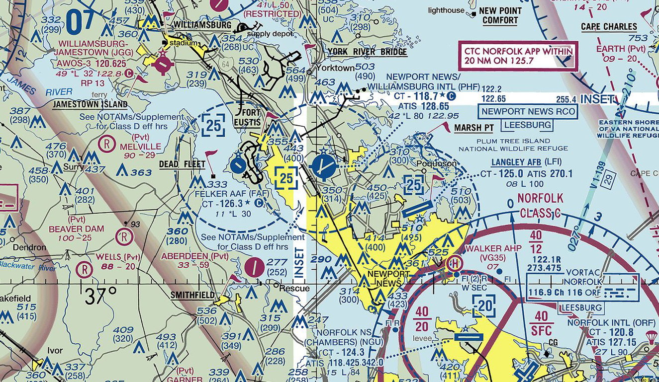
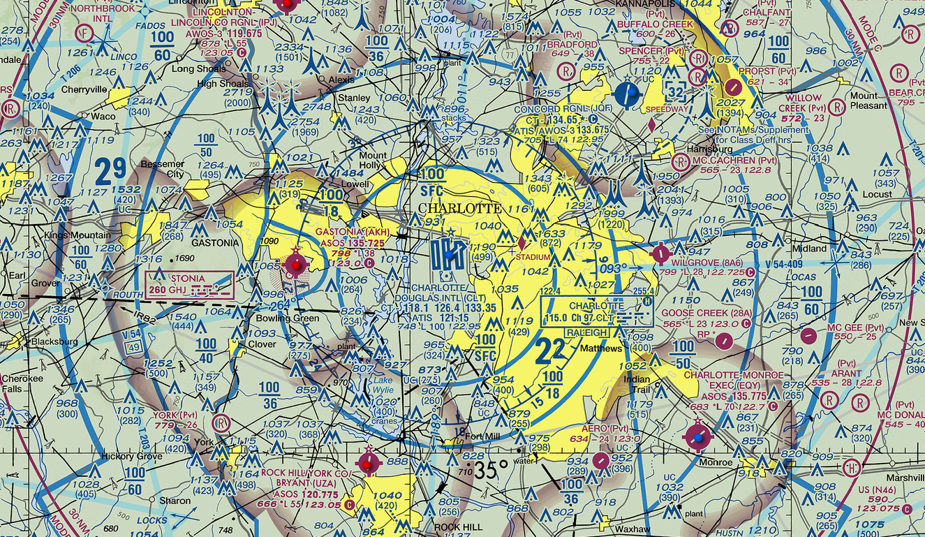
Class D airspace is controlled airspace and is depicted with a dashed/segmented blue circle/lines and typically includes airspace from the surface (SFC) up to 2,500 feet MSL. The ceiling of Class D airspace is denoted by a 2-digit number inside a dashed blue square [25] which indicates 2,500 feet MSL. There’s three (3) Class D airports in this images which shows Williamsburg/Newport News airport (in the center), an Army-Air Force airport to its left, and Langley Air Force base to its right. All three airports are in controlled airspace that extends 5 NM outwards from the center of each airport and upwards to 2,500 feet MSL (as denoted by the number [25] in blue dashed boxes). All of these airports are towered as denoted by the blue circle with runway icons inside the blue circles. Again, a blue star indicates airports with a lighted beacon that’s on from sunset to sunrise, and the blue squares attached to Williamsburg-Newport News airport icon indicate fuel services are available.
Notice the Class D (dashed) airspace to the southeast that’s nestled with an outer shelf of Class C airspace; that Class C airspace shelf runs from 2,000 feet MSL to 4,000 feet MSL. This Class D airspace has a minus sign in front of the [-20] which means the Class D airspace is “up to but not including 2,000 feet MSL.” So the Class D airspace extends from the SFC to 1,999 feet MSL and then the Class C run from 2,000 to 4,000 feet MSL.
Also notice the magenta flags to the southwest and northwest of Williamsburg-Newport news airport, as those are Visual Flight Rules (VFR) reporting points which are used by air traffic control (ATC) and pilots to navigate. Remote pilots in command should expect to see higher volumes of manned aircraft in these areas. The black lettering is the name of the reporting point (Smithfield and Jamestown Island). There’s also three more VFR flags as well… Williamsburg, York River Bridge and March Point. See if you can find those.
Class E Controlled Airspace

Class E airspace can be shown as either a dashed magenta line/circle or as a shaded magenta circle, and it can also be shown as a shaded blue circle/line but that type of airspace will primarily be seen in the western United States at higher elevations. Class E airspace with dashed magenta lines typically includes airspace from the surface (SFC) up to 1,200 feet MSL, but sometimes it can be higher depending on the geographical location. That is, Class E airspace could run into the lower shelf of Class B or C airspace, or the lower shelf of Class E blue-shaded airspace at 14,500 feet MSL, or extend all the way up to 17,999 feet MSL which is the bottom of Class A airspace. The outside of this faded magenta Class E airspace includes airspace from 1,200 feet AGL up to but not including 18,000 feet MSL but again, the ceiling can vary depending if another airspace reside on top of the Class E airspace such as the Class C airspace we previously reviewed. The majority of Class E airspace sits on top of uncontrolled Class G airspace.
Class E airspace is controlled airspace, and the magenta airport icon confirms this airport is non-towered. The airspace extends 5 NM outward from the center of the airport, and the magenta star denotes a lighted beacon and the protruding square indicate fuel services are available to this airport. Since it’ a non-towered airport, manned pilots obtain airport and weather information from automated weather operating systems such as AWOS or ASOS, which will be reviewing in another lesson.
There’s dozens of reasons why it’s important for remote pilots to understand the National Airspace System (NAS). For example, if you were hired you inspect the top of some broadcasting towers (obstacles) located due north of Hot Springs Memorial, which are depicted as two “M’s” with the numbers 1620 and 460, you would need to know if you are required to obtain FAA authorization to fly in that area. These particular group of obstacles (likely cell or broadcasting towers), are 1,620 feet MSL and 460 feet AGL. Since remote pilot are allowed to fly 400 feet higher than the upper most top of a tower of structure, you’d know you could easily fly 200 feet over the top of that tower and still be well under the lower shelf of that 700 foot AGL Class E airspace. The same is true with the tower southwest of Hot Springs Airport. The tower near Lambert is 330 feet AGL so could easily fly up to 350 feet AGL over the top of that tower and you’d be still be below the lower shelf of that 700 foot AGL Class E airspace.
Incidentally, the blue dashed circle that looks like a compass is a compass rose used my manned pilots, but will not pertain to the remote pilot.
Sectional Chart Icons
 Blue airport icon indicates it is a towered airport. The star indicates it has a beacon light operable from sunset to sunrise, and the three squares indicate the airport has fuel services. You can also tell this airport is in Class D airspace because there’s a blue [25] which is only found inside blue dashed Class D airspace. Airports denoted in circles represent runways from 1,500 to 8,069 feet in length, and the actual length of the runways are stated in the Aeronautical Sectional Chart or Chart Supplement U.S.. As previously mentioned, an airport with just a runway icon (not in a colored circle) denotes runways exceeding 8,069 feet in length.
 This is a non-towered airport as indicated by the magenta circle. The star indicates the airport has a beacon light operating from sunset to sunrise, and the three square indicates fuel services. Also within this example are two magenta flags which indicates VFR checkpoints used by ATC for pilot reporting points. Also shown is the parachute icon indicating there may be parachute jumpers in the area too.
 Another image of a non-towered airport with lighted beacon and fuel services, and the dotted circle means there a non-directional beacon (NDB) at this airport. Also shows a group of obstacles (stacks) nearby that are 404 feet AGL. Again, all of these icons will be in the Airmen Knowledge booklet that will be given to you during the exam, which you can easily refer to during the exam.
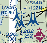 Group of obstacles, likely cell or broadcasting towers. The numbers on top denote the height of the structures in Mean Sea Level (MSL) and the numbers in parentheses below denote height in Above Ground Level (AGL). The middle tower with the lightening bolts indicates a lighted tower. The tall icons depict a tower that is 1,000 feet tall or higher AGL, and the shorter icons indicate a tower/obstacle that is less than 1,000 feet tall AGL. Remember, part 107 permits you to fly your sUAS no higher than 400 feet AGL above the upper-most height of a tower or structure, providing your sUAS does not run into any controlled airspace.
 Group of obstacles/structures that are under 1,000 feet AGL. Obstacles less than 1,000 feet AGL will be shown as shorter icons. The lighted structure is 1,029 feet MSL, 620 feet AGL, and the “UC” next to (620) indicates the structure is under construction. It also states the obstacles are “stacks & tower.” There’s also a restricted airport denoted by the “R” inside a magenta circle.
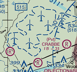 This is a group of wind turbines and as a remote pilot, you would obviously want to be aware of the presence of these wind turbines before scheduling any operations in the area. Also notice three restricted airports, which are either private or require authorization before landing. The airport on the right is clearly labeled private (Pvt) with the name of the airport.
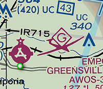 Next to this non-towered airport with lighted beacon and fuel services, is a glider icon indicating one can expect to see glider activity in the vicinity specifically, glider activity where the glider is towed by a motorized aircraft. A“U” in place of the “G” would indicate an ultralight aircraft, and an “H” would indicate hang gliders could be expected in the area.
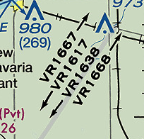 The VR1667 numbers indicate military training routes where one can expect low-altitude high-speed flight training from the surface to but not including 1,500 feet AGL. Four numbers indicate flight altitude below 1,500 feet AGL and two or three numbers indicate flight training from 1,500 feet AGL and higher (i.e.: VRxxxx or IRxxxx = below 1,500 feet AGL and VRxxx or IRxx indicate flight above 1,500 AGL. We’ll be reviewing VR and IR flight routes in another lesson, but the numbers bear no indication on flight altitude.
 Isogonic lines are depicted in this image as the dashed straight magenta line labeled 9° West. You may not be asked the definition, but you may be asked what its name is on the exam. The line indicates the magnetic variation or difference between true north and magnetic north. Also note the high-speed military training routes indicated as The VR41, VR1754 and IR760 are military training routes (MTR) to conduct high-speed training missions using either Visual Flight Rules (VFR/VR) or Instrument Flight Rules (IFR/IR). Again, the numbers following the letters do not depict true altitude but rather, they simply tell you if flights will be above 1,500 feet AGL or below 1,500 feet AGL. Routes at or below 1500 AGL are indicated by a four-digit number and flights above 1500 AGL are typically indicated by three or fewer numbers.
 A Victor Airway is a straight-line that’s used to depict low-altitude civilian air traffic and is shown as a thick faded blue line on the sectional chart (a few years ago they used to be depicted as black lines). Victor Airways are identified by a number, similar to military VFR and IFR traffic patterns, but Victor Airways are designated as Class E airspace extending from a base of 1,200 feet AGL up to 18,000 feet MSL. The width of Victor Airways extend 4 miles in each direction of the center line (8 miles wide) and provide a 1,000 foot AGL clearance over the highest obstacle in its path. As you can see in this image, there’s a few towers that are close to the Victor Airways that a remote pilot should be aware of if performing operations in the area.
Airport Data Information
Here are a few examples of how to read information on any given airport found within an Aeronautical Sectional Chart.
 Dallas Fort Worth Airport
CT = Operational Control Tower
124.95 , 126.55, 127.5, 134.9 = Control tower frequencies.
Some larger airport may only have 1 or 2 frequencies.
ATIS 123.775 = Automated weather frequency
607 = Airport elevation 607 feet MSL
L = Full time lighted beacon
134 = Length of runway in hundreds of feet (13,400 foot runway)
122.95 = UNICOM frequency
AOE = Airport of Operations which means airport provides customs and immigration services for incoming flights.
 Myrtle Beach International Airport
CT = Operational control tower
128.45 = Control tower frequency
Star = Control tower is part time.
C = CTAF also 128.45
ATIS = Automated weather terminal services
123.925 = Automated weather service frequency
25 = Airport elevation of 25 feet MSL
*L = Part time lighted beacon
95 = Length of runway in hundreds of feet (9,500 foot long runway)
122.95 = UNICOM frequency
RP 18 = RP means right turn approach for flight traffic. Common procedure is left turns, except when noted.
18 = the runway for right turn pattern.
Latitude and Longitude
Latitude and longitude are used to measure the location of the various landmarks designated on the sectional chart. The horizontal lines that run east and west represent latitude and they’re used to measure the degrees of latitude north or south of the equator.
Hint: Latitude = Lateral.
The vertical lines that run north to south represent longitude and they’re used to measure the degrees of longitude west or east of the Prime Meridian. The Prime Meridian passes through Greenwich, England, and this area is referred to as Zulu Time for pilots or as Greenwich Mean Time.
Latitude is the measure “West” and longitude is the measurement “North.” Latitude and longitude are measured using degrees marked as a °. There’s 180° of latitude that encompass 90° north of the equator and 90° south of the equator, and there’s 360° of longitude which encompass 180° east of the Prime Meridian and 180° west of the Prime Meridian around the earth.
The United States is west of the Prime Meridian and north of the equator so all measurements will be “north” and “west.” Latitude and longitudes are measured in degrees, minutes and seconds as °, ‘ and “. Be aware there may be a few questions on the exam that may have the latitude and longitude written in decimal format so if you receive that style of question, here’s the formula to solve it.
46.9N, 98.6W = 46º 54’N, 98º 36’W
46 = 46º
.9 x 60 = 54 = 46º 54’N
98 = 98º
.6 x 60 = 36 = 98º 36’W

In the above example, you can see 38 degrees north latitude and 109 degrees west longitude at the bottom of the image. That would be written as 38° 0′ North, 109° 0′ West. We can omit the seconds for our purposes right now. Each notch is a “tick” or minute, and there’s a total of 60 minutes between degrees and a total of 30 minutes in each quadrant. Each larger notch or tick equates to 10 minutes.

In the above example, we see several examples of how to locate and pinpoint a structure which a company may ask you to locate and inspect. You’ll likely have a few questions asking whether a structure is located within a controlled airspace and/or what type of airspace a structure might be located within. None of the structures referenced by the arrows are within controlled airspace however, there are a few structures that are located within the Class E airspace. Remember, this Class E airspace begins at 700 feet AGL so would you be able to inspect the top of the towers shown below “Wakefield?” The answer is YES!
Remember, remote pilots are permitted to fly a maximum of 400 feet higher than the upper most limits of a structure so providing you do not penetrate into the lower ceiling of the Class E controlled airspace above (700 feet AGL), you are allowed to inspect the top of those towers. You would only be allowed to fly 285 feet higher before penetrating into the Class E controlled airspace.

Maximum Elevation Figure (MEF)
A MEF represents the highest altitude a manned pilot can fly and clear all manmade or vertical obstacles, as well as natural terrain, within a quadrant of latitude and longitude 30 minutes by 30 minutes. There are two methods used to achieve the MEF: one method used depends on whether the highest obstacle in the quadrant is manmade, and the other method used depends on whether the highest elevation is naturally made.
The MEF is denoted in blue numbers where the larger number represents thousands of feet and the smaller number represents hundreds of feet. In this example, we see a manned pilot could fly at 2,600 feet MSL and still clear all manmade and/or natural obstacles in this quadrangle. In this quadrant, the highest elevation is a manmade obstacle at 2,477 feet MSL, which is in a red circle. So to adjust and reach the MEF of 2,600, 100 feet is added to 2,477 feet, and then 2,577 is rounded up to 2,600 feet MSL.
2,477 ft
+ 100 ft
2,577 ft or 2,600 feet MSL
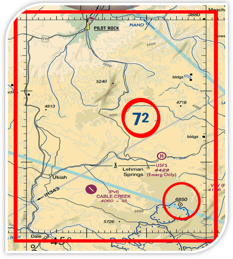
In this quadrant, the MEF is 7,200 feet MSL and aside from a small obstacle or oil rig near Lehman Springs, we see the highest elevation is a natural elevation of 6,850 feet MSL. Since the highest elevation is natural, a different formula is used to achieve the MEF by adding an additional 200 feet as follows:
6,850 ft
+ 100 ft
+ 200 ft
7,150 feet rounded up to 7,200 feet MSL
Congratulations! You’ve finished Lesson 3 on Aeronautical Sectional Charts. Be sure to click the COMPLETE button below to register your progress.
1. The floor of the controlled airspace overlying the Sandpoint Airport is:
2. What is the floor of the Savannah Class C airspace at the shelf area (outer circle)?
The floor and ceiling of this Class E Airspace is denoted by the 41 over 13. This tells us that the floor of the airspace is 1,300 feet MSL and the ceiling is 4,100 feet MSL. The faded aspect of the magenta circle tells us the inside of the airspace circle, the floor of that airspace, begins at 700 feet AGL. The outside of the faded circle tells us the floor of that surrounding Class G Airspace begins at 1,200 feet MSL.
3. You’re inspecting the tower located approximately at 46° 8′ N and 98° 6′ W. Who do you need prior authorization from?
4. What does the line of latitude measure at 46° north?
5. Why would the small flag at Lake Drummond in area 2 of the sectional chart be important to a remote pilot?
6. With FAA authorization, you’re operating your sUAS approximately 4 SM southeast of Elizabeth City Airport (ECG). What hazard is indicated to be in that area?
7. What is the height of the lighted obstacle approximately 6 NM southwest of Savannah Int’l Airport?
8. You’re to inspect a lighted tower approximately 13 miles south-southwest of Minot Airport. What will be your maximum flying altitude?
9. What is the floor of the Class B airspace at Addison Airport?
10. What is the approximate latitude and longitude of Cooperstown Airport?
11. What’s the height of the tallest group of towers approximately 13 miles due-south of Minot Airport?
12. You’re hired to inspect the railroad tracks between Hinton and Winnebago. Will you need FAA authorization to complete this operation?

