
Aviation Weather and Its Effects on Small Unmanned Aircraft
Density Altitude
The characteristics of the atmosphere has a major effect on performance of an aircraft and the two dominant factors that affect flight are pressure and temperature. The definition of density altitude is, pressure altitude correct for non-standard temperature; often described as the altitude where your aircraft feels like it’s flying. To further explain, the standard air temperature and pressure at sea level is 15º Celsius with the barometric pressure at 29.92” Hg (inches of mercury). A standard day is when an aircraft is at sea level with the temperature at 15° Celsius and barometric pressure at 29.92” Hg. So on a standard day, that is when pressure altitude and density altitude are equal.
Lower density altitude (closest to sea level) provides the best performance and thereby increases an aircraft’s performance but conversely, as an aircraft rises into the atmosphere, the air density decreases and an aircraft’s performance decreases. Air density is affected by changes in altitude, temperature, and humidity. A decrease in air density means a high density altitude. The conditions that result in a high density altitude are high elevations, low atmospheric pressures, high temperatures, high humidity, or some combination of these factors. An increase in air density means a lower density altitude. Lower elevations, high atmospheric pressure, low temperatures, and low humidity are more indicative of low density altitude.
Standard air temperature and pressure at sea level is 15º Celsius at 29.92” Hg (inches of mercury).
Altitude/Elevation/Pressure
Since air is a gas, it can be compressed or expanded and when air is compressed, a greater amount of air can occupy a given volume. Conversely, when pressure on a given volume of air is decreased, the air expands and occupies a greater space thereby decreasing the density. Density is directly proportional to pressure so if the air pressure is doubled, the density is doubled. If the pressure is lowered, so is the density. However, this is true only at a constant temperature.
Temperature: Increasing the temperature of a substance decreases its density and conversely, decreasing the temperature increases the density. Therefore, the density of air varies inversely with temperature but this is true only at a constant pressure. In the atmosphere, both temperature and pressure decrease with altitude and have conflicting effects upon density. However, the fairly rapid drop in pressure as altitude is increased usually has the dominant effect. Hence, pilots can expect the density to decrease with altitude.
Three Main Factors Affecting Density Altitude
High Temperatures: The warmer the air, the less dense the air will be. The air is less dense and adds to an increase in density altitude.
High Humidity: More water vapor means less air mass. The more water vapor or water molecules that are in the air displaces the air molecules thereby, creating less air for propellers to grab a hold of.
High Elevation: At a higher altitude/elevation, the air becomes less dense.
If you were to launch your sUAS at “ground level” at an altitude of 2,000 feet above mean sea level (MSL), you will begin flying with decreased performance when compared to flying at sea level.
There are fives types altitudes that the FAA wants you to understand because they all affect how your aircraft performs at any given altitude. The different types of altitudes are:
Absolute Altitude: The height an object is at above ground level (AGL).That is, you could be at 2,000 feet MSL but when you’re sUAS is still on the ground, you and your aircraft are at 0 AGL. This is Absolute Altitude.
True Altitude: The height of an object or location above mean sea level (MSL).It is the actual level above seas level you and your sUAS are at. So if you are launching your sUAS at 2,000 feet MSL, 2000 feet MSL is your True Altitude.
Indicated Altitude: The height or altitude your altimeter displays. Regarding sUAS flight, most altimeters assume you’re at sea level under standard conditions, where indicated altitude is the same as true altitude.
Pressure Altitude: The indicated altitude when the barometric pressure scale is set to 29.92 in Hg (inches of mercury). Pressure Altitude doesn’t determine temperature.
Density Altitude: The pressure altitude corrected for non-standard temperature. This is the altitude that we’ve said that the aircraft or sUAS feels like it’s flying. Air density is affected by changes in altitude, temperature, and humidity. High density altitude refers to thin air while low density altitude refers to dense air. The conditions that result in a high-density altitude are high elevations, low atmospheric pressures, high temperatures, high humidity, or some combination of these factors. Lower elevations, high atmospheric pressure, low temperatures, and low humidity are more indicative of low density altitude. So if higher density altitude means thinner air, you’ll experience reduced aircraft performance. Your propellers or motors don’t have as much “air” to grab on to. Lower density altitude means thicker, denser air, and stronger aircraft performance.
Higher Density Altitude Occurs at:
- Higher Elevations
- Lower Atmospheric Pressures
- Higher Temperatures
- Higher Humidity
Lower Density Altitude Occurs at:
- Lower Elevations
- Higher Atmospheric Pressures
- Lower Temperatures
- Lower Humidity
As mentioned, density altitude is the altitude at which your aircraft feels like it’s flying, and perfect density altitude will provide a great flight. As temperature and altitude increase, air density decreases. On a hot and humid day, an aircraft may accelerate more slowly, or may need to move faster, making it more difficult for the aircraft to climb. With humid air, there’s fewer oxygen molecules for propellers to grab onto to create lift. At a higher altitude, although it may be less humid, there’s fewer air/oxygen molecules so a propeller has less air to grab onto for lift. Also, as air pressure decreases, the less lift and as air pressure increase, lift is easier to attain. Performance is the term used to describe the ability for an aircraft to accomplish certain things that make it useful for certain purposes. The primary factors most affected by performance are the takeoff and landing distance, rate of climb, ceiling, payload, range, speed, maneuverability, stability, and fuel economy.
Climb Performance Factors
Since weight, altitude, and configuration-changes affect excess thrust and power, they also affect climb performance. Climb performance is directly dependent upon the ability to produce either excess thrust or excess power. Weight has a very pronounced effect on aircraft performance as well. If weight is added to an aircraft, it must fly at a higher angle of attack (AOA) to maintain a given altitude and speed. But by increasing the AOL, we increase the induced drag of the wings, as well as the drag of the aircraft. Increased drag requires additional thrust to overcome the drag, which in turn means that less reserve thrust is available for climbing. Aircraft designers go to great lengths to minimize the weight, since it has such a direct effect on the factors pertaining to performance. Drag is caused by moving a solid object through a fluid medium, such as the atmosphere. A change in an aircraft’s weight produces a twofold effect on climb performance. An increase in altitude also increases the power required and decreases the power available. Therefore, the climb performance of an aircraft diminishes with altitude.
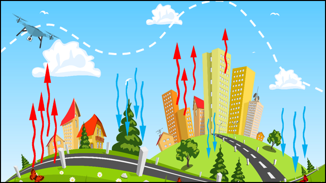
Convective Currents
Wind patterns, circulation, speed and wind temperatures are directly affected by buildings, manmade structures, and geological features such as mountains, lakes, farms, trees. Surfaces like bare soil or ground, rocks, sand, and roads radiates large amounts of heat and objects and matter like lakes, oceans, ponds, trees, forests, and vegetation, tend to absorb and retain heat. This uneven heating of the air creates small areas of local circulation called convective currents.
In part, convective currents are the forces that cause bumpy turbulent air when flying at lower altitudes during warmer weather. So if a Remote Pilot were to fly an aircraft over pavement or sand, he/she should expect to experience updrafts during flight. And if the remote Pilot were to fly an sUAS over a lake, body of water, or open sandy field, or a groups of trees or forest, he/she could experience downdrafts.
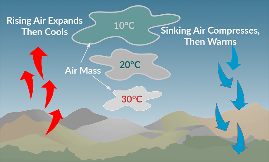
Adiabatic Heating and Cooling
When air rises, it expands and then cools. And when air descends, it compresses and the temperature increases. This temperature change is known as adiabatic heating and adiabatic cooling. As the air increases in altitude, the rate at which the temperature decreases is referred to as its lapse rate. As air ascends through the atmosphere, the average lapse rate is 2° Celsius per 1,000 feet in unsaturated air. The combination of temperature and moisture determine the stability of the air and the resulting weather. Cool, dry air is very stable and resists vertical movement, which leads to good and generally clear weather. Stratiform clouds may be present in this case. This lapse rate is how a remote pilot in command can determine the stability of the atmosphere; to get a sense of how stable or unstable the atmosphere might be. The bigger the gap between the lapse rate, the more unstable the atmosphere.
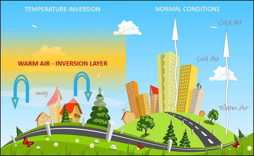
Temperature Inversion
As air rises and expands in the atmosphere, the temperature decreases. There is an atmospheric anomaly that can occur; however, that changes this typical pattern of atmospheric behavior. When the temperature of the air rises with altitude, a temperature inversion exists. Inversion layers are commonly shallow layers of smooth, stable air close to the ground. The temperature of the air increases with altitude to a certain point, which is the top of the inversion. The air at the top of the layer acts as a lid, keeping weather and pollutants trapped below. If the relative humidity of the air is high, it can contribute to the formation of clouds, fog, haze, or smoke resulting in diminished visibility in the inversion layer. Surface-based temperature inversions occur on clear, cool nights when the air close to the ground is cooled by the lowering temperature of the ground. The air within a few hundred feet of the surface becomes cooler than the air above it. Frontal inversions occur when warm air spreads over a layer of cooler air, or cooler air is forced under a layer of warmer air.
Atmospheric Stability, Pressure, and Temperature
Every change in weather is the direct result of a heat exchange. The stability of the atmosphere correlates with its ability to resist vertical motion, so a stable atmosphere makes vertical movement of air difficult, and an unstable atmosphere allows an upward or downward disturbance to grow into a vertical (or convective) current. Instability can lead to significant turbulence, extensive vertical clouds, and severe weather.
Relative Humidity
Humidity refers to the amount of water vapor present in the atmosphere at a given moment. Relative humidity is the actual amount of moisture in the air compared to the total amount of moisture the air could hold at that temperature. For example, if the current relative humidity is 65 percent, the air is holding 65 percent of the total amount of moisture that it is capable of holding at that temperature and pressure.
Temperature / Dew Point Relationship
The dew point, given in degrees, is the temperature at which the air cannot hold any more moisture. As moist, unstable air rises, clouds often form at the altitude where temperature and dew point reach the same value. At this point, the air is completely saturated, and moisture begins to condense out of the air in the form of fog, dew, frost, clouds, rain, hail, or snow. Typically, when the temperature and the dew point converge, you will have fog. For example, if the outside air temperature is 64°F and the dew point is 59°F and it is dusk (i.e. temperature is falling), you will most likely have fog or low clouds as the temperature and dew point converge.
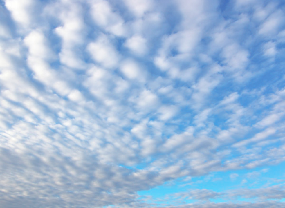
Stratiform Clouds
Stable Air
Every change in weather is the direct result of a heat exchange, and the stability of the atmosphere depends on its ability to resist vertical motion. With a stable atmosphere, vertical movement of air is difficult and small vertical disturbances dampen out and disappear (think how you sometimes see smoke from a fire only rising 50-100 feet, then drifting slowly away horizontally). Cool, dry air is very stable and resists vertical movement, which leads to good and generally clear weather. However, clear weather doesn’t mean good visibility. Stable air tends to produce:
Stratiform clouds
Smooth air
Fair-to-poor visibility with haze and smoke
Continuous precipitation
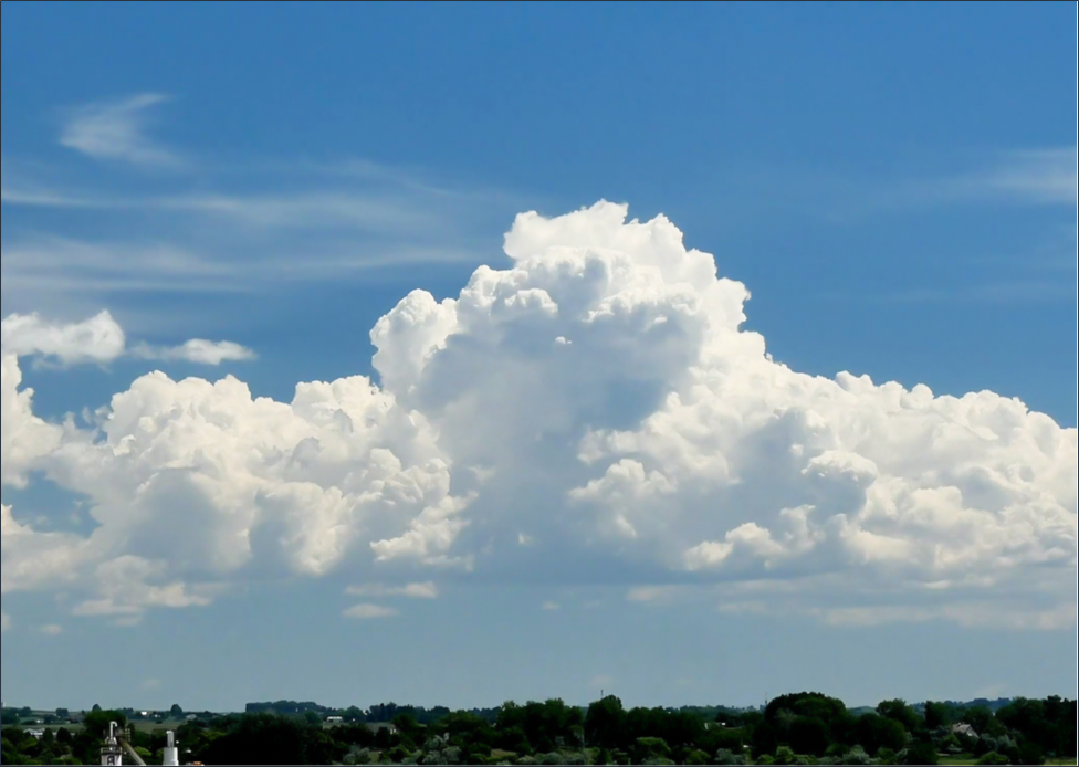
Cumulonimbus Clouds
Unstable Air
With an unstable atmosphere, small vertical air movements tend to become larger, resulting in turbulent airflow and convective activity. Instability can lead to significant turbulence, extensive vertical clouds, and severe weather. The combination of moisture and temperature determine the stability of the air and the resulting weather. The greatest instability occurs when the air is moist and warm, as it is in the tropical regions in the summer. Typically, thunderstorms appear on a daily basis in these regions due to the instability of the surrounding air. Unstable air tends to produce:
Cumuliform clouds
Turbulent air
Good visibility
Showery precipitation
Air Masses and Weather Frontal Systems
Air Masses and Fronts
Air masses are large bodies of air that move throughout the atmosphere and when slow-moving air masses move over an area that has a uniform temperature and moisture characteristics, the air mass absorbs those temperatures and moisture characteristics. Two of these air masses that we need to remember are maritime tropical air masses and continental polar air masses.
Polar air mass: forms over a polar region and brings cool, dry air with it.
Tropical air mass: forms over warm tropical waters and brings warm, moist air with it.
When an air mass passes over a warmer surface, that air mass is warmed from below and this causes convective currents to form, which causes the air to rise. When the air rises, this creates an unstable air mass with good surface visibility. This moist, unstable air has good visibility, but it also causes turbulence, cumulus clouds, and showers. As an air mass moves across bodies of water and land, it eventually comes in contact with another air mass that has different characteristics; two different air masses or areas of pressure.
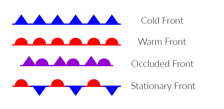
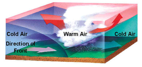
An approaching front of any type always means that weather changes are imminent, and there will always be a change in the wind direction temperature. Fronts are named according to the temperature of the advancing air relative to the temperature of the air it is replacing. While no two fronts are the exact same, there are four basic categories of fronts:
Cold front
Warm front
Occluded front
Stationary front
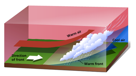
Warm Front: A warm front happens when a warm mass of air advances and replaces a body of colder air. As the warm air is lifted, the temperature drops and condensation occurs. A warm front often has high humidity. Also, warm fronts move slowly, typically 10 to 25 mph.
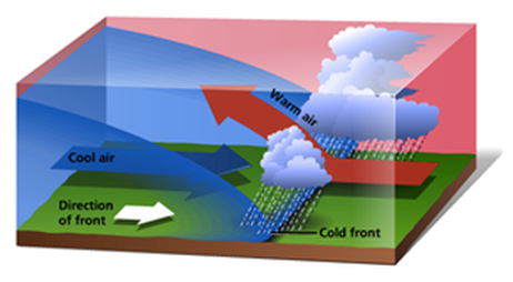
Cold Front: A cold front happens when a cold, dense, mass of stable air advances and replaces a body of warmer air. Cold fronts move twice as fast as warm fronts, usually progressing at a rate of 25 to 30 mph. However, extreme cold fronts have been recorded moving at speeds of up to 60 mph. Usually, a cold front moves in a manner opposite that of a warm front. This cold, stable air is really dense, so it stays close to the ground and acts kind of like a snowplow sliding under the warmer air and forcing the less dense air aloft.
Warm vs. Cold Fronts
Weather Activity: While warm fronts bring low ceilings, poor visibility, and rain, cold fronts bring sudden storms, gusty winds, turbulence, and sometimes hail or tornadoes. A cold front can be characterized by its shifting wind conditions and violent weather.
Approach Speed: Warm fronts provide advance warning of their approach and can take days to pass through a region. Cold fronts are fast approaching with little or no warning, and they make a complete weather change in just a few hours.
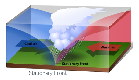
Stationary Front: When the forces of two air masses are relatively equal, the boundary or front that separates them remains stationary and influences the local weather for days. This front is called a stationary front. The weather associated with a stationary front is typically a mixture that can be found in both warm and cold fronts.
Occluded Front: An occluded front occurs when a fast-moving cold front catches up with a slow-moving warm front. There are two types of occluded fronts that can occur, and the temperatures of the colliding frontal systems play a large part in defining the type of front and the resulting weather, but we don’t have to go into great detail about these type of fronts.
Wind Shear and Microbursts
Wind shear is dangerous to an aircraft as it can cause sudden drastic change in wind speed and/or direction over a very small area which can cause violent updrafts and downdrafts, as well as abrupt horizontal movement of an aircraft; wind shear rapidly changes the performance of the aircraft and disrupts normal flight attitude. Although wind shear can occur at any altitude, low-level wind shear is especially hazardous due to the proximity of an aircraft to the ground.
Low-level wind shear is commonly associated with passing frontal systems, thunderstorms, temperature inversions, and strong upper level winds (greater than 25 knots).
Wind shear is dangerous to an aircraft as it can rapidly change the performance of the aircraft and disrupt normal flight attitude. For example, a tailwind quickly changing to a headwind causes an increase in airspeed and performance. Conversely, a headwind changing to a tailwind causes a decrease in airspeed and performance. In either case, a pilot must be prepared to react immediately to these changes to maintain control of the aircraft.
It is important to remember that wind shear can affect any flight at any altitude.
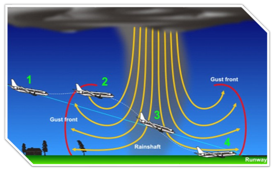
One type of wind shear is a microburst. A microburst is associated with convective precipitation, which is shorter and more intense. A microburst typically occurs in a space of less than one mile across horizontally and within 1,000 feet vertically and only last about 5 to 15 minutes. A microburst can produce a headwind of 30–90 knots which during that time, can produce severe downdrafts of up to 6,000 feet per minute. Microbursts can also produce a hazardous wind direction change of 45 degrees or more in a matter of seconds and are often difficult to detect because they occur in relatively confined areas. Many airports around the country have wind shear alert systems to warn pilots called, the low-level wind shear alert system (LLWAS).
A microburst is the most severe type of low-level wind shear and is associated with convective precipitation. Activity may be indicated by an intense rain shaft at the surface with vertical rain bands hanging down at the cloud base and a ring of blowing dust is often the only visible clue. Remember, wind shear can affect any flight and any pilot at any altitude so remote pilots must always be alert to the possibility of wind shear, particularly when flying in and around thunderstorms and frontal systems. Wind shear is always not visible and serve wind shear can always be expected in a temperature inversion whenever wind speed at 2,000 to 4,000 ft. AGL is 25 knots or more.
The atmosphere contains moisture in the form of water vapor and the amount of moisture present in the atmosphere is dependent upon the temperature of the air. An increase in temperature by just 20°F doubles the amount of moisture the air can hold and in reserve, a decrease of 20°F reduces the amount of moisture the air can hold by half. Water is present in the atmosphere in three states: liquid, solid, and gaseous and all three can readily change into another. Liquid, solid, and gaseous liquid all are present within all temperature ranges of the atmosphere and as water changes from one state to another, an exchange of heat takes place. These changes occur through the processes of evaporation, sublimation, condensation, deposition, melting, and freezing.
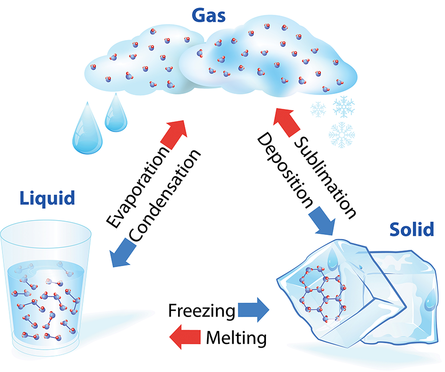
The only way water vapor is added into the atmosphere is through evaporation or sublimation.
Evaporation: changing of liquid water to water vapor.
Sublimation: changing of ice to water vapor bypassing the liquid stage.
Cumulonimbus clouds are perhaps the most dangerous type of cloud, appearing individually or in groups as either an air mass or orographic thunderstorm. Heating of the air near the earth’s surface creates an air mass thunderstorm. Cumulonimbus clouds that form in a continuous line are non-frontal bands of thunderstorms or squall lines. Since rising air currents cause cumulonimbus clouds, remote pilots could experience serious updrafts and downdrafts, plus a lot of rain (nimbus means “rain”).
Lenticular Clouds
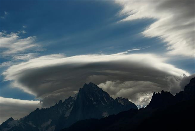
Lenticular clouds are formed by barriers in the wind flow and are most prevalent around mountaintops. Lenticular clouds show little movement, hence the name standing clouds however, the presence of lenticular clouds is a good indication of very strong turbulence and should be avoided.
Stages of a Thunderstorm

First Stage/Cumulus Stage: A thunderstorm begins with the cumulus stage, in which lifting action of the air begins. If sufficient moisture and instability are present, the clouds continue to increase in vertical height resulting in wind shear and turbulence. Continuous, strong updrafts prohibit moisture/rain from falling and the updraft region grows larger than the individual thermals feeding the storm.
Second Stage/Mature Stage: Within approximately 15 minutes, a thunderstorm reaches its mature stage which is the most violent time period of the thunderstorm’s life cycle. At this point, drops of moisture, whether rain or ice, are too heavy for the cloud to support and begin falling in the form of rain or hail creating a downward motion of the air. Warm, rising air with cool, precipitation-induced descending air, combined with violent turbulence, all exist within and near the cloud. Below the cloud, the down-rushing air increases surface winds and decreases the temperature.
Third Stage/Dissipating Stage: Once the vertical motion near the top of the cloud slows down, the top of the cloud spreads out and takes on an anvil-like shape and at this point in the cloud’s lifecycle, the storm enters the dissipating stage. This is when the downdrafts spread out and replace the updrafts needed to sustain the storm.
Calculating Cloud Base
As moist unstable air rises, clouds often form at the altitude where the temperature and dew point reach the same value. As a remote pilot, you’re going to want to understand how to calculate the cloud base to know how far under the clouds you should be operating under at any given time. Remember, part 107 states that a remote pilot must operate at least 500 feet below clouds, and the elevation at which the cloud base can form depends on the temperature and the dew point. The difference between the surface temperature and the dew point is known as the spread. Divide the spread by 4.4 if temperatures are in °F, or 2.5 if temperatures are in °C, and then multiply by 1,000 for the Cloud Base AGL.
Example: Temperature is 75 °F and dew point is 70 °F
75 – 70 = 5 (5 = the spread)
5/ 4.4 = 1.14
1.14 x 1,000 = 1,140
Cloud base is 1,140 feet Above Ground Level (AGL)
Icing: Icing on any aircraft is not good, and all pilots should be alert for icing anytime the temperature approaches 0°C and when there’s visible moisture in the air. In freezing temperatures, ice can accumulate on your sUAS frame where it can no longer sustain flight, and this condition is known as airframe icing and under certain conditions, airframe icing can occur very quickly. Freezing rain can immediately freeze upon contact, negatively changing the aerodynamic qualities of the propellers. Any presence of frost or ice will dramatically and negatively affect an aircraft’s ability to fly.
Hail: The anticipation of hail should be expected with any thunderstorm, especially beneath the anvil of a large cumulonimbus cloud. Like lightening, hail can be encountered in clear weather, several miles away from any thunderstorm clouds. It’s doesn’t take a lot of force to knock a sUAS out of the sky, so take weather and hail very seriously during all weather conditions.
Lightning: Lightning cannot only damage or destroy your sUAS, it can also ruin your flight controller and other electronic equipment and induce permanent errors in the magnetic compass. Even if lightening strikes far away from your operating area, it can disrupt radio communications and the delicate electronic systems in your sUAS and system, as well as pose danger to yourself and ground crew too.
Tornadoes: It goes without saying that a remote pilot should never operate their sUAS near tornadic weather, the FAA just wants the remote pilot to be aware tat a severe thunderstorm could spawn tornadic activity, even if it’s miles away from the main thunderstorm cloud.
Ceiling and Visibility
As mentioned, remote pilots must fly their sUAS no closer than 500 feet below a cloud and 2,000 feet horizontally away from a cloud, and maintain a minimum flight visibility of 3 statute miles (SM).
Ceiling: For aviation purposes, a ceiling is the lowest layer of clouds reported as being broken or overcast, or the vertical visibility into an obscuration like fog or haze; clouds are reported as broken when five-eighths to seven-eighths of the sky is covered with clouds. Overcast means the entire sky is covered with clouds, and current ceiling information is reported by a METAR weather report, or Meteorological Terminal Aviation Routine Weather Report.
Visibility: Closely related to cloud cover and reported ceilings is visibility information. Visibility refers to the greatest horizontal distance at which prominent objects can be viewed with the naked eye. Current visibility is also reported in METAR and other aviation weather reports, as well as by automated weather systems. Visibility information, as predicted by meteorologists, is available for a pilot during a preflight weather briefing.
Fog: Fog is a cloud that typically forms within 50 feet of the surface when the temperature of air near the ground is cooled to the air’s dew point. At this point, water vapor in the air condenses and becomes visible in the form of fog. Fog is classified according to the manner in which it forms and is dependent upon the current temperature and the amount of water vapor in the air. There are five types of fog that can form: advection fog, radiation fog, steam fog, upslope fog, and ice fog.
Advection Fog: Coastal Areas – Sea Breezes
Advection fog forms when warm air mass moves over cold surface, such as land. Wind of up to 15 knots is required for advection fog to form and intensify, and can persist for days. When winds exceed 15 knots, the fog usually lifts and forms low stratus clouds. Advection fog is common in coastal areas where sea breezes can blow the air over cooler landmasses.
Radiation Fog: Low Lying Areas – Mountain Valleys
Radiation fog can development on clear nights with relatively little to no wind present, and it usually forms in low-lying areas like mountain valleys. This type of fog occurs when the ground cools rapidly due to terrestrial radiation, and the surrounding air temperature reaches its dew point. An increase in wind speeds the dissipation of radiation fog and as the sun rises and the temperature increases radiation fog lifts and eventually burns off. If radiation fog is less than 20 feet thick, it is known as ground fog.
Upslope Fog: Mountain Slopes
Upslope fog occurs when moist, stable air is forced up sloping land features like a mountain range. This type of fog requires wind for formation and continued existence. Upslope and advection fog, unlike radiation fog, may not burn off with the morning sun but instead can persist for days. Upslope fog can also extend to greater heights than radiation fog too.
Steam Fog
Steam fog, or sea smoke, forms when cold, dry air moves over warm water. As the water evaporates, it rises and resembles smoke. This type of fog is common over bodies of water during the coldest times of the year. Low-level turbulence and icing are commonly associated with steam fog.
Ice Fog
Ice fog occurs in cold weather when the temperature is much below freezing and water vapor forms directly into ice crystals. Conditions favorable for its formation are the same as for radiation fog except for cold temperature, usually –25 °F or colder. Ice fog primarily occurs in the arctic regions but is not unknown in middle latitudes during the cold season.
Congratulations! You’ve completed Chapter 4 on Aviation Weather and Its Effects of Weather on your sUAS. Be sure to click the COMPLETE button below to register your progress.
1. What are characteristics of a moist unstable air mass?
2. If an unstable air mass is forced upward, what type of clouds can be expected?
3. Which factor would tend to increase the density altitude at a given airport?
4. A stable air mass is most likely to have which characteristic?
5. Generally for aircraft, the most hazardous kind of thunderstorm is:
6. Moisture is added to air by:
7. What should you expect if you see lenticular clouds over a mountain?
8. Advection fog will most likely form when:
9. What is the standard air temperature and pressure at sea level?
10. When is pressure altitude equal to density altitude?
11. What are characteristics of unstable air?
12. Where does wind shear occur?

