
Aviation Weather Sources
Weather Reporting Systems
In aviation, weather service is a combined effort of the National Weather Service (NWS), Federal Aviation Administration (FAA), Department of Defense (DOD), other aviation groups and individuals ad these reports and forecasts enable pilots to make informed decisions regarding weather and flight safety before and during a flight.
Surface Aviation Weather Observations
Surface aviation weather observations are a compilation of elements of the current weather at individual ground stations across the United States. The network is made up of government and privately contracted facilities that provide continuous up-to-date weather information. Automated weather sources, such as the Automated Weather Observing Systems (AWOS), Automated Surface Observing Systems (ASOS), as well as other automated facilities, also play a major role in the gathering of surface observations. Surface observations provide local weather conditions and other relevant information for a specific airport. This information includes the type of report, station identifier, date and time, modifier (as required), wind, visibility, runway visual range (RVR), weather phenomena, sky condition, temperature/dew point, altimeter reading, and applicable remarks. The information gathered for the surface observation may be from a person, an automated station, or an automated station that is updated or enhanced by a weather observer. In any form, the surface observation provides valuable information about individual airports around the country, and these reports cover a small area that will be beneficial to the remote pilot.
METAR Weather Reports
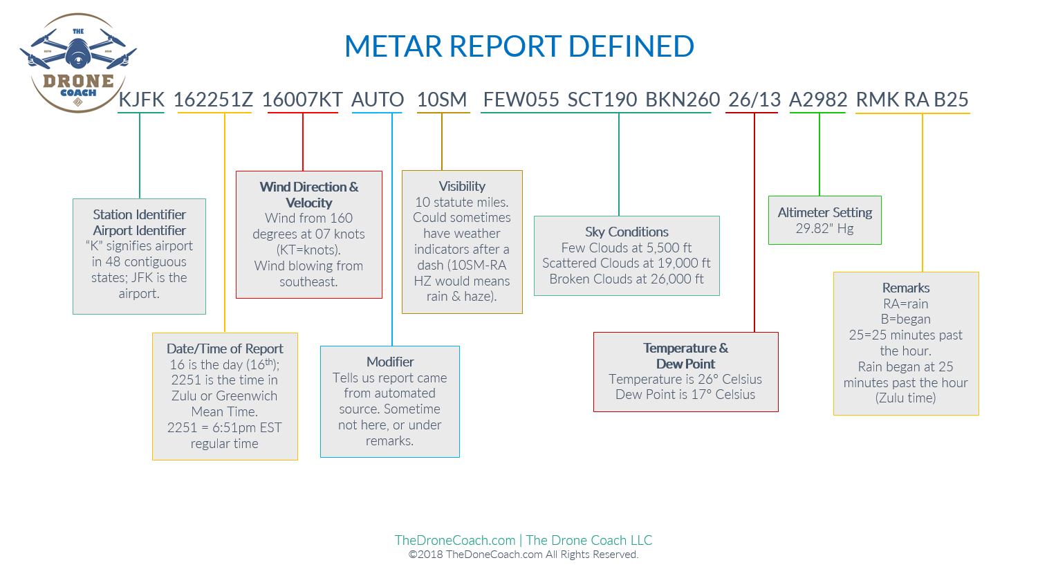
METAR KJFK 162251Z 16007KT AUTO 10SM FEW055 SCT190 BKN260 26/13 A2982 RMK RAB25
Aviation weather reports are designed to give accurate depictions of current weather conditions. Each report provides current information that is updated at different times. Some typical reports are METARs and PIREPs. To view a weather report, go to https://www.aviationweather.gov/.
An Aviation Routine Weather Report (METAR) is an observation of current surface weather and are issued on a regularly scheduled basis unless significant weather changes have occurred. A special METAR (SPECI) can be issued at any time between routine METAR reports. Here is an example of a group of METAR’s what we will be reviewing in great detail. I know this report can be slightly intimidating at first but after a little study, it will become second nature. We encourage you to review this chapter as often as necessary until you know this information, as questions about METAR’s will be in your final FAA exam.
There are two types of METAR reports: METAR and SPECI. METAR’s are generated and transmitted on a regular time interval, typically every hour. The second type of weather report is a SPECI, which is a special report that can be given at any time to update the METAR for rapidly changing weather conditions, aircraft mishaps, or other critical information. A typical METAR report contains the following information in sequential order:
METAR KJFK 162251Z 16007KT AUTO 10SM FEW055 SCT190 BKN260 26/13 A2982 RMK RAB25
Type of Report: The first notation “METAR” denotes the type of report and in this case, this is a the METAR report. “METAR” may not always be displayed in the class exam but you will know which page and chart to review during your exam.
Station Identifier: a four-letter code (KJFK) as established by the International Civil Aviation Organization (ICAO). In the 48 contiguous states, a unique three-letter identifier is preceded by the letter “K” followed by the airport 3-letter identifier. In other regions of the world, including Alaska and Hawaii, the first two letters of the four-letter ICAO identifier indicate the region, country, or state. Alaska identifiers begin with the letters “PA” and Hawaii identifiers begin with the letters “PH.”
Date and Time of Report: depicted in a six-digit group (162251Z). The first two digits are the current date (16th) and the last four digits are the time of the report. Manned pilots always use Zulu time (Z), so all reports will be given in Zulu time. Zulu time is synonymous with Greenwich Mean Time and Coordinated Universal Time (UTC). Remote pilots should practice converting Zulu time, and adjusting for daylight savings time if applicable.
METAR KJFK 162251Z 16007KT AUTO 10SM FEW055 SCT190 BKN260 26/13 A2982 RMK RAB25
Wind: typically reported with five digits (16007KT), unless wind gusts are involved. The first three digits indicate the direction the true wind is blowing from in tens of degrees so in this example, the wind is blowing from 160 degrees, which is from the south southeast. If the wind is variable, the report will show “VRB” (160VRB07KT). The last two digits indicate the speed of the wind in knots and in this example, the wind is blowing at 7 knots. If the winds are gusting, the letter “G” will be noted followed the wind speed (160G0718KT). Although it may appear the “gusts” and actual speed numbers are flipped, it is not. 160G0718KT reads as: winds blowing from 160 (degrees), gusts 18 knots, wind speed 7 knots. If the wind direction varies more than 60° and the wind speed is greater than six knots, a separate group of numbers, separated by a “V,” will indicate the extremes of the wind directions.
Modifier: denotes that the METAR came from an automated (AUTO) source, or that the report was corrected. If the notation “AUTO” is listed in the METAR, the report came from an automated source. When the modifier “COR” is used, it identifies a corrected report sent out to replace an earlier report that contained an error (METAR KJFK 162251Z COR). A Modifier is not always present and sometimes is denoted under the remarks sections as “AO1” (for no precipitation discriminator) or “AO2” (with precipitation discriminator). The A01 or A02 indicate the type of precipitation sensors employed at the automated station.
Visibility: the prevailing visibility (10SM) is reported in statute miles as denoted by the letters “SM.” It is reported in both miles and fractions of miles and sometimes the runway visual range (RVR) will be noted following the prevailing visibility. RVR is the distance a pilot can see down the runway in a moving aircraft and when RVR is reported, it is shown with an R, then the runway number followed by a slant, then the visual range in feet. For example, when the RVR is reported as R17L/1400FT, it translates to a visual range of 1,400 feet on runway 17 left.
METAR KJFK 162251Z 16007KT AUTO 10SM FEW055 SCT190 BKN260 26/13 A2982 RMK RAB25
Sky condition: always reported in the sequence of amount, height, and type or indefinite ceiling/height (vertical visibility). In the example, we see FEW055 SCT190 BKN260 which translates to: few clouds at 5,500 feet AGL; scattered clouds at 19,000 feet AGL; broken clouds at 26,000 feet AGL. The heights of the cloud bases are reported with a three-digit number in hundreds of feet AGL. Clouds above 12,000 feet are not detected or reported by an automated station. The types of clouds, specifically towering cumulus (TCU) or cumulonimbus (CB) clouds, are reported with their height. Contractions are used to describe the amount of cloud coverage and obscuring phenomena. The amount of sky coverage is reported in eighths of the sky from horizon to horizon.
Temperature and dew point: the air temperature and dew point are always given in degrees Celsius (C). Temperatures below 0 °C are preceded by the letter “M” to indicate minus. Weather can also be broken down into two different categories: qualifiers and weather phenomenon. First, the qualifiers of intensity, proximity, and the descriptor of the weather are given. The intensity may be light (–), moderate ( ), or heavy (+). Proximity only depicts weather phenomena that are in the airport vicinity. Not shown in this example, the notation “VC” would indicates a specific weather phenomenon is in the vicinity of five to ten miles from the airport. Descriptors are used to describe certain types of precipitation and obscurations.
Altimeter setting: reported as inches of mercury (“Hg) in a four-digit number group (A2982) and is preceded by the letter “A.” Rising or falling pressure may also be denoted in the “Remarks” sections as “PRESRR” or “PRESFR,” respectively.
Remarks: the remarks section always begins with the letters “RMK.” Comments may or may not appear in this section of the METAR. The information contained in this section may include wind data, variable visibility, beginning and ending times of particular phenomenon, pressure information, and various other information deemed necessary. An example of a remark regarding weather phenomenon that does not fit in any other category would be: OCNL LTGICCG which means, occasional lightning in the clouds [OCNL LTGC] and from cloud to ground [CG].
TAF Weather Reports | Aviation Weather Forecasting
Observed weather condition reports are often used in the creation of forecasts for the same area. A variety of different forecast products are produced and designed to be used in the preflight planning stage. The printed forecasts that pilots need to be familiar with are the terminal aerodrome forecast (TAF), aviation area forecast (FA), inflight weather advisories such as the Significant Meteorological Information (SIGMET), Airman’s Meteorological Information (AIRMET), and the winds and temperatures aloft forecast (FB). Well review each of these throughout this section.
Terminal Aerodrome Forecasts (TAF)
A TAF is a report established for the five statute mile radius around an airport and are usually given for larger airports. Each TAF is valid for a 24 or 30 hour time period and is updated four times a day at 0000Z, 0600Z, 1200Z, and 1800Z. The TAF utilizes the same descriptors and abbreviations as used in the METAR report, and these weather reports can be beneficial to the remote pilot for flight planning purposes.
The TAF includes the following information in sequential order:
- Type of Report – A TAF can be either a routine forecast (TAF) or an amended forecast (TAF AMD).
- ICAO Station Identifier – The station identifier is the same as that used in a METAR.
- Date and Time of Origin – The time and date (121720Z) of TAF origination is given in the six number code with the first two being the date, the last four being the time. Time is always given in UTC as denoted by the Z following the time block.
- Valid Period Dates and Times – The TAF valid period (1218/1324) follows the date/time of forecast origin group. Again, scheduled 24 and 30 hour TAFs are issued four times per day, at 0000, 0600, 1200, and 1800Z. The first two digits (12 and 13) are the day of the month for the start of the TAF, and the next two digits (18 and 24) are the starting hour (UTC). The 13 is the day of the month for the end of the TAF, and the last two digits (24) are the ending hour (UTC) of the valid period. A forecast period that begins at midnight UTC is annotated as 00. If the end time of a valid period is at midnight UTC, it is annotated as 24. For example, a 00Z TAF issued on the 12th of the month and valid for 24 hours would have a valid period of 1200/1224.
- Forecast Wind – The wind direction and speed forecast are coded in a five-digit number group. In this example we see 20012KT where the first three digits indicate the direction (200 °) of the wind in reference and the last two digits state the wind speed in knots (12 knots) appended with “KT.” Like the METAR, winds greater than 99 knots are given in three digits.
- Forecast Visibility – Given in statute miles and may be in whole numbers or fractions. If the forecast is greater than six miles, it is coded as “P5SM.”In this example, 5SM is followed by haze (HZ).
- Forecast Significant Weather – Weather phenomena are coded in the TAF reports in the same format as the METAR.
- Forecast Sky Condition – Given in the same format as the METAR. Only CB clouds are forecast in this portion of the TAF report as opposed to CBs and towering cumulus in the METAR.
- Forecast Change Group – For any significant weather change forecast to occur during the TAF time period, the expected conditions and time period are included in this group. This information may be shown as from (FM), and temporary (TEMPO). “FM” is used when a rapid and significant change, usually within an hour, is expected. “TEMPO” is used for temporary fluctuations of weather, expected to last less than 1 hour.
- PROB30 – A given percentage that describes the probability of thunderstorms and precipitation occurring in the coming hours. This forecast is not used for the first 6 hours of the 24-hour forecast.
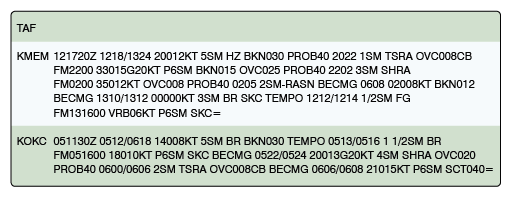
Example: TAF KPIR 111130Z 1112/1212 16015G25KT 6SM SCT040 BKN250 FM120000 14012KT P6SM BKN080 OVC150 PROB30 1200/1204 3SM TSRA BKN030CB FM120400 1408KT P6SM SCT040 OVC080 TEMPO 1204/1208 3SM TSRA OVC030CB=
Explanation: Routine TAF for Pierre, South Dakota… on the 11th day of the month, at 1130Z… valid for 24 hours from 1200Z on the 11th to 1200Z on the 12th. Wind from 160° at 15 knots, gusting to 25 knots. Visibility greater than 6 SM. Clouds scattered at 4,000 feet and broken at 25,000 feet. From 0000Z wind from 140° at 12 knots visibility greater than 6 SM. Clouds broken at 8,000 feet, overcast at 15,000 feet. Between 0000Z and 0400Z, visibility 3 SM, thunderstorm with moderate rain showers, clouds broken at 3,000 feet with cumulonimbus clouds. From 0400Z, winds 140° at 8 knots, visibility greater than 6 miles, clouds at 4,000 scattered, overcast at 8,000. Temporarily between 0400Z and 0800Z, visibility 3 statute miles, thunderstorms with moderate rain showers. Clouds overcast at 3,000 feet with cumulonimbus clouds. End of report (=).
METAR/TAF/Weather Abbreviations
We’ve highlighted some of the most common uses you may find on the final exam.
AO1 – Automated Observation without precipitation discriminator (rain/snow)
AO2 – Automated Observation with precipitation discriminator (rain/snow)
AMD – Amended Forecast (TAF)
BKN – Broken
CLR – Clear at or below 12,000 feet (AWOS/ASOS report)
COR – Correction to the observation
DSNT – Weather phenomena beyond 10sm of the observation point
FEW1 or 2 octas (eighths) cloud coverage
FM – From (4 digit beginning time in hours and minutes)
OVC – Overcast
P6SM – Visibility greater than 6 SM (TAF only)
PK WND – Peak Wind
PRESFR – Pressure falling rapidly
PRESRR – Pressure rising rapidly
PROB40 – Probability 40 percent
RMK – Remark
RY/RWY – Runway
SCT – Scattered
SKC – Sky Clear
SM – Statute mile(s)
SPECI – Special Report
TEMPO – Temporary changes expected (between 2 digit beginning hour and 2 digit ending hour)
VC – Vicinity
VRB – Variable wind direction when speed is less than or equal to 6 knots
WS – Wind shear (In TAFs, low level and not associated with convective activity)
DESCRIPTORS
DR – Low Drifting
FZ – Supercooled/freezing
MI – Shallow
PR – Partial
SH – Showers
TS – Thunderstorm
WEATHER PHENOMENA
BLPY – Blowing spray
BR – Mist (think “baby rain”)
DS – Dust Storm
DU – Widespread Dust
DZ – Drizzle
FC – Funnel Cloud
+FC – Tornado/Water Spout
FG – Fog
FU – Smoke
GR – Hail
GS – Small Hail/Snow Pellets
HZ – Haze
IC – Ice Crystals
PL – Ice Pellets
PO – Dust/Sand Whirls
RA – Rain
SA – Sand
SN – Snow
SNINCR – Snow increasing rapidly
SQ – Squall
SS – Sandstorm
CLOUD TYPES
ACSL – Altocumulus or Lenticular
CB – Cumulonimbus
CCSL – Cirrocumulus
SCSL – Stratocumulus
TCU – Towering Cumulus
Convective Significant Meteorological Information (WST)
Convective SIGMETs are issued for severe thunderstorms with surface winds greater than 50 knots, hail at the surface greater than or equal to ¾ inch in diameter, or tornadoes. They are also issued to advise pilots of embedded thunderstorms, lines of thunderstorms, or thunderstorms with heavy or greater precipitation that affect 40 percent or more of a 3,000 square mile or greater region. A remote pilot will find these weather alerts helpful for flight planning.
Automated Terminal Information Service (ATIS)
Again, I just wanted to reiterate the Automated Terminal Information Service (ATIS) is a recording of the local weather conditions and other pertinent non-control information broadcast on a local frequency in a looped format. It is normally updated once per hour but is updated more often when changing local conditions warrant. Important information is broadcast on ATIS including weather, runways in use, specific ATC procedures, and any airport construction activity that could affect taxi planning.
When the ATIS is recorded, it is given a code. This code is changed with every ATIS update. For example, ATIS Alpha is replaced by ATIS Bravo. The next hour, ATIS Charlie is recorded, followed by ATIS Delta and progresses down the alphabet.
Congratulations! You’ve completed Chapter 5 on Aviation Weather Sources. Be sure to click the COMPLETE button below to register your progress.
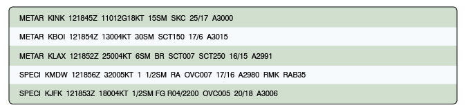
1. What is the valid period for the TAF for Memphis Int’l Airport KMEM?
2. TAFs are typically valid for:
3. Between 1000Z and 1200Z the visibility at KMEM is forecast to be?
4. What are the current conditions for Chicago Midway Airport KMDW?
5. What are the wind conditions at Wink, Texas KINK?
6. A TAF covers an area:
7. What is the wind direction and velocity at KJFK?
8. In a METAR report, what does “BR” indicate?
9. In the remarks section of the METAR for Midway Airport (KMDW), what does RAB35 indicate?
10. Which direction is the wind blowing from at Los Angeles Nat’l Airport KLAX?
11. What is the altimeter reading at Boise Int’l Airport KBOI?
12. What was the day and time the weather report was given at Winkler County Airport (KINK)?
